

HOW TO
Obtain a Public Safety Airspace Authorization
Last updated: 9/14/26
Overview
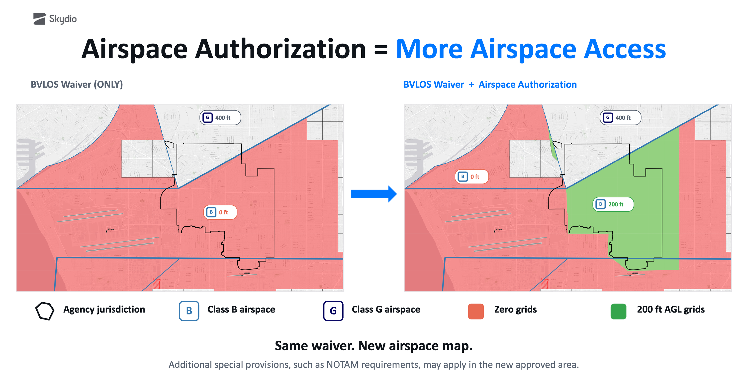
Standard Part 91 Beyond Visual Line of Sight (BVLOS) Certificates of Waiver (waiver) include a provision, such as Provision 11 below, that authorizes operations in controlled airspace below the UAS Facility Map altitudes only.

To conduct operations above UAS Facility Map altitudes, there are two types of additional authorization your agency can seek:
- Part 91 Airspace Authorization
- 2-year authorization for routine operations
- Approval in 60 days or less
- Submitted via FAA COA Application Process System (CAPS) web portal
- Special Government Interest (SGI) approval
- Issued and valid only for specific emergencies. See the FAA’s SGI guide here.
- Approval in real- or near real-time
- Submitted in FAA / TSA Waiver & Airspace Access Program web portal.
This rest of this guide includes detailed instructions for requesting a Part 91 Airspace Authorization.
NOTE: All examples provided in this guide are to be used for educational and reference purposes only.
Part 91 Airspace Authorization Process Overview

Gain accesss to CAPS
Part 91 airspace authorization requests are submitted in an FAA Portal called COA Application Processing System (CAPS), not DroneZone. The FAA creates CAPS accounts for agencies upon request and requires two documents: a CAPS Access Form and a Public Declaration Letter.
Public Declaration Letter
The FAA allows entities to self-certify their public aircraft status when requesting a Part 91 BVLOS waiver, but does not allow entities to self-certify when requesting a Part 91 airspace authorization in CAPS.
Therefore, your agency must obtain a written declaration letter, called a Public Declaration Letter, created by an entity that is in a position to determine that your agency is qualified to operate as a Public Aircraft Operator in accordance with 49 USC § 40102(a)(41) and 49 USC § 40125(a)(1). The entity may be a City Attorney, County Attorney, State Attorney General, or an entity under legal contract with the public agency.
Public Declaration Letter resources and examples:
Public safety agencies that meet the definition of 49 USC § 40102(a)(41)(A) or (B) do not need to declare this status with a Public Declaration Letter, but may be asked by the FAA to provide another form of evidence.
CAPS Access Form
The CAPS Access Form must be filled out by the individual that will submit applications in the CAPS portal.
CAPS Access Form link and example:
Submit Public Declaration Letter and CAPS Access Form to the FAA
The finalized Public Declaration Letter and completed CAPS Access Form are emailed to 9-AJV-115-UASOrganization@faa.gov for FAA review and acceptance. In the email, indicate that you are requesting access to the CAPS to submit COAs on behalf of your agency.
The FAA will review the request and upon acceptance, create a CAPS login for the user and email address noted on the CAPS Access form. It may take up to 15 business-days for the FAA to establish an account within the online program that is partitioned to allow for security of the data that the public agency enters.
The FAA will provide further instructions on how to access the CAPS account.
Develop proposal and safety case
When requesting to operate above the UAS Facility Map Altitudes, the FAA needs to know where your agency wants to fly and at what altitude(s). This information is used as part of the FAA’s safety analysis to determine if the request is approved, approved with changes, or denied. Skydio recommends creating graphics, an associated shapefile (like a KML/KMZ), and further documentation explaining any additional safety mitigations being implemented.
The following section provides additional tips and tools to put this material together. Another great resource is Episode 6 of the Skydio webinar series Regulatory Updates for Public Safety that discusses how to develop your proposal starting at the 6:42 mark.
What are UAS Facility Maps?
UAS Facility Maps "UASFM” show the maximum altitudes around airports where the FAA authorizes operations under the Part 91 waiver discussed above and without further safety analysis. The following excerpt from the FAA describes how UASFM altitudes are picked:
“Local airport facility Air Traffic Controllers, staff, and managers worked collaboratively to determine UASFM altitudes. These FAA employees reviewed manned aviation approach and departure procedures, aircraft and helicopter operations, and a variety of other factors to determine where small UAS operations could operate safely. If a request for an operation includes an altitude above what is displayed on the UASFM, it may still be approved but would need coordination with the facility and additional FAA safety analysis.”
In practical terms, UASFM altitudes are typically zero (no fly) over the airport and altitude gradually increases as the distance from the runway increases. Zero grids protect aircraft on approach, departure, or in the traffic pattern. They can also be configured around heliports (such as The Lutheran Hospital of Indiana below), for security reasons, or for common low-altitude flight paths.

When developing the areas and altitudes your agency intends to request, consider where low flying crewed aircraft will be present. UASFM altitudes indicate where the FAA has determined drones can safely operate without additional safety risk assessment. Typically, there’s an area of “zero grids” directly over the airport and additional zero grids extending from each runway’s centerline. Grid numbers (allowed altitude AGL) the gradually increase as distance from the runway increases. Zero grids protect aircraft on approach, departure, or in the traffic pattern. They can also be configured around heliports, for security reasons, or for common low-altitude flight paths.
Requesting to operate above these altitudes triggers a safety risk assessment and the success of the application depends on your agency’s ability to mitigate the risk of encountering low altitude crewed aircraft in the requested area.
Step 5: Request Airspace Authorization in CAPS
The Skydio Regulatory Team has developed a guide for filling out the COA application in CAPS.

As an example, proposing to operate at 0.25 NM from the end of a runway could put the drone directly in a crewed aircraft’s final approach to land, and the FAA might deny such a request. However, if your agency proposes to operate 1 NM from the runway at 200 feet AGL, the FAA is more likely to approve the request as it is below the typical flight paths.
A similar analysis was done for heliports:

In addition to carefully choosing the proposed operating area, Skydio recommends including other safety mitigations in the request:
- Explain the geofencing capabilities of the sUAS
- Explain the loss of link procedures
- Explain how the RPIC will use ADS-B to remain clear of crewed aircraft
Create a GIS file and graphic of the requested area and altitude
A Geographic Information Systems (GIS) file and graphic representation of the proposed flight areas and altitudes must be included in the request for the FAA and airport to review. These files are important for two reason:
- They assist the FAA and airport understand exactly where you’re requesting to operate and conduct an efficient safety review.
- Once approved, a GIS file of the final approved area and altitudes can be uploaded in Skydio DFR Command as a map layer. This assists RPICs in knowing exactly where the drone is relative to the approved flight area and can be used to create accurate geofences
Skydio recommends agencies use one of the following tools to create the GIS file and graphic:
- FAA UAS Visualize It
- Google Earth or Google Earth Pro
- GeoJSON.io
Each tool has a drawing feature that can be used to outline the requested flight area(s). Once the flight area(s) are defined, they can be exported and saved.
FAA Visualize It Drawing Tool Example
- Open FAA’s Visualize it, navigate to your jurisdiction, and select the Draw button in the upper left.
- Use the provided shapes to outline the requested flight areas.
- Once finished, use the Export button in the Draw toolbar to download the shape(s) as a .json file.
- Take a screenshot of the flight area and add a caption over the top of the picture indicating what altitude you’re requesting.


Resources
The Skydio Regulatory Team has created an example airspace authorization document that combines the proposal graphic and additional safety mitigation information together into one document: Airspace Authorization Request Template.
Contact local ATC facility prior to submission
The following step is highly recommended and encouraged, but is optional.
Once you’ve developed the initial proposal, Skydio recommends proactively contacting the airport and requesting to meet with airport management stakeholders to review the proposal. Each airport typically has one individual, often an FAA employee, who is responsible for responding to requests to operate above the UAS Facility Maps. This meeting provides an opportunity to brief the airport on your DFR program, hear if they have any areas of concern, refine the map and requested altitudes, and agree on a general framework that may help improve approval timelines before the request enters the formal review queue. Below is a suggested meeting agenda to help guide the discussion.
Airport DFR Meeting Guiding Agenda
- Introductions
- What is DFR and why is your agency implementing it
- Areas of Operations
- Frequency of Operations
- Highlight the BVLOS waiver your agency holds and provide a copy
- Discuss the Skydio X10 and capabilities
- Discuss operating above the UAS Facility Map altitudes (0-200’ grids)
- Discuss the requested area(s) and altitude(s)
- Have a graphic / KML ready to discuss
- If comfortable doing so, offer to give the airport a demo or host them at your agency to show them.
An example agenda with additional detail is available: ATC Discussion Agenda Detailed.
Submit request in CAPS
Once your agency has an airspace authorization proposal prepared, and ideally coordinated with the airport, it gets submitted in the FAA CAPS system. Skydio has prepared a separate detailed guide for completing this application: Part 91 Airspace Authorization CAPS Guide.
CAPS Documents
- CAPS Guide
- Airworthiness Statement
- Lost Comms
- Skydio X10 Abnormal and Emergency Procedures
- Skydio X10 Lost Link Procedures
Processing Time
Processing time can take up to 60 days but varies depending on the complexity of the request and airport workloads. Monitor your email for any correspondence from the FAA.
Approval!
The FAA will issue a signed airspace authorization via email and also add it to your CAPS account. Read the airspace authorization carefully to understand and comply with the provisions and requirements.
Additional Resources
References
The following FAA sources were used to develop this guidance and can provide additional details:
Feedback and Questions
If you find an error in this guide, have recommendations for improving it, or have questions, let us know by contacting the Skydio Regulatory Team at aviation_regulatory@skydio.com.