


Skydio continues to improve features for the X2D - America's world-class leading small drone
 Skydio
Introduction
The Skydio X2D drone has established itself globally as a top choice for government agencies, defense forces, and commercial enterprises that need drones with military-grade data and cyber security. With cutting-edge technology and exceptional performance, Skydio is constantly improving the features of the X2D to meet the evolving needs of operators. In this blog, we will explore the new and improved features of the X2D, including updated RAS-A Compliance, Map Capture, Crosshair Coordinates, Dynamic Obstacle Avoidance, and Stop at Structure.
RAS-A compliance
Skydio is committed to safe and secure flight and proactively partners with the government to expand drone applications and integration solutions. One of the key improvements to the Skydio X2D is enhanced compliance with the Robotics and Autonomous Systems – Air (RAS-A) Interoperability Profile (IoP) federal standard. By enhancing X2D’s open MAVLink protocol support through ongoing adoption of the evolving RAS-A MAVLink dialect, Skydio continues to enable X2D’s autonomous capabilities to support a broader ecosystem of integrations, and simplifies adoption of Skydio vehicles and their associated data products into third-party systems. Skydio’s RAS-A interface enables a wide variety of platform capabilities such as motion primitives with obstacle detection and avoidance, camera and payload control, object detection, autonomous track and follow, radio and data link configuration, and improved media compatibility. Skydio is committed to common interfaces such as RAS-A, and is dedicated to providing simple and user-friendly standardization and compatibility of Skydio drones with third-party flight applications and controllers.
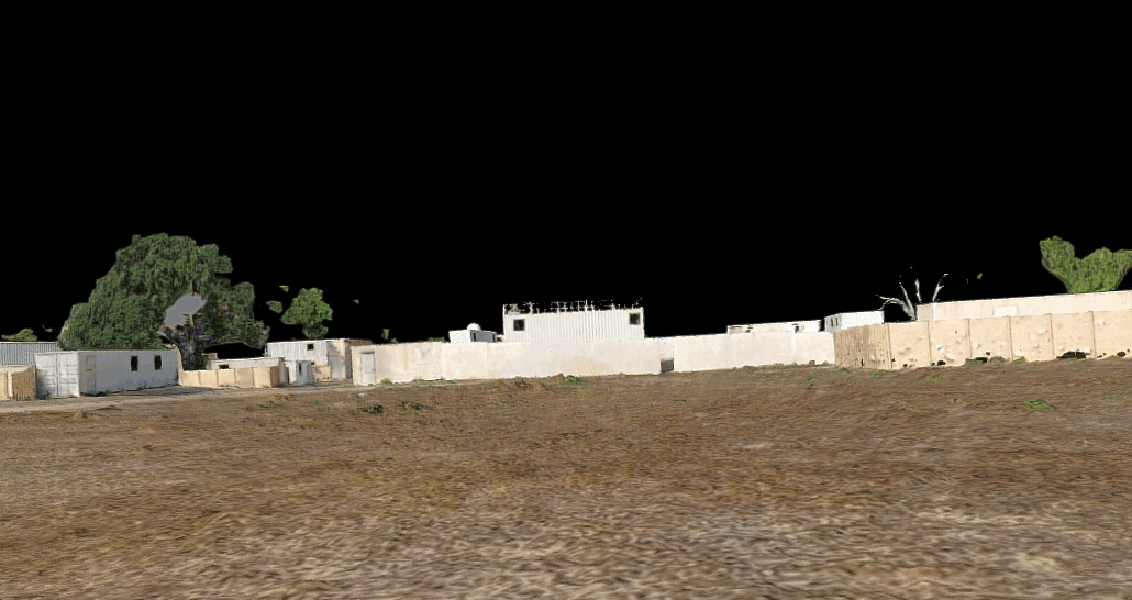
Map Capture
In response to the growing need for rapid and accurate mapping and surveying, Skydio has designed Map Capture for Skydio drones. This feature allows users to generate high-resolution 2D maps of areas of interest with ease. Advanced imaging capabilities, combined with intelligent mapping algorithms, enable operators to create detailed and precise maps for a wide range of applications, such as terrain mapping, infrastructure inspections, environmental monitoring, disaster management, and battle damage assessment. Map capture is now included as a standard feature in all federal Skydio X2D enterprise packages.
Use cases: Map capture is an excellent tool for airfield mapping, damage inspections of airfields or auxiliary airfields, or assessing the viability of an area that could be used as an HLZ or expeditionary runway. It can also be used to scan an objective area prior to a mission to obtain accurate and timely information about the environment and operating area - for example, an operating zone planned for satellite patrols that have been recently bombed or physically modified by an adversary or friendly action.
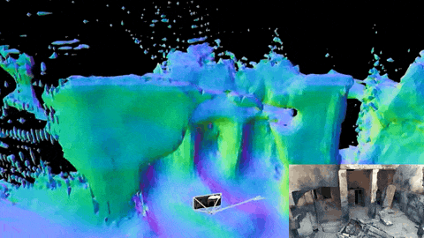
Battle damage assessment
Skydio Map Capture can be used to provide a detailed Battle Damage Assessment (BDA). A Skydio X2D can be rapidly deployed to the target area following an engagement. Equipped with high-resolution cameras for real-time aerial surveillance, the X2D can quickly collect and process detailed imagery to help military analysts assess damage and confirm successful hits on intended targets. Rapid and precise information from the assessment enables the ground to make better-informed decisions to capture fleeting opportunities, or quickly adapt to new developments on the battlefield. Map Capture thus enhances situational awareness and reduces risks to ground personnel, while contributing to more rapid refinements of tactical and operational strategies, giving forces equipped with Skydio X2D a tactical edge. Units that require even higher-fidelity battlefield re-creation (for example, Explosive Ordnance Disposal (EOD) analysis, military law enforcement forensics, and war crimes investigators), can purchase the Skydio 3D Scan, which provides a detailed three-dimensional representation of a surveyed battle area.
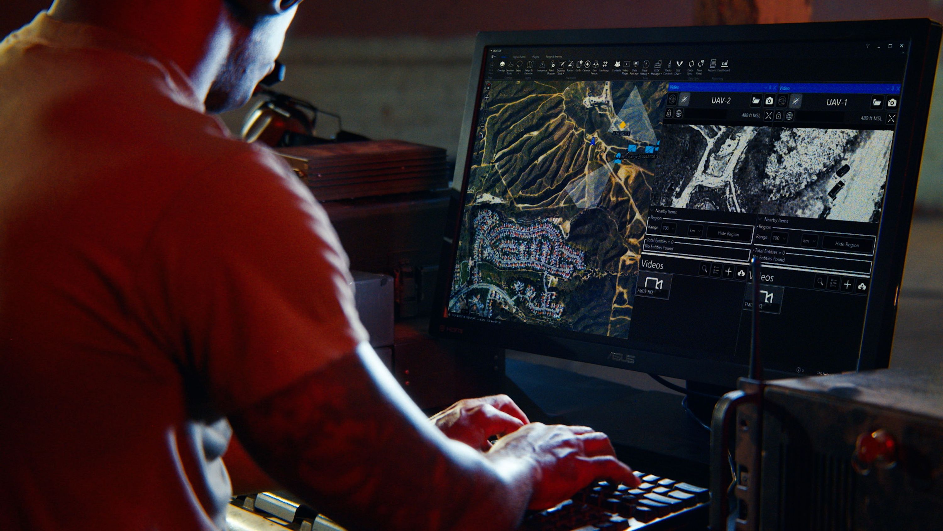
Obtaining coordinates
The new software release provides two ways for X2D users to generate coordinates.
- Triangulation skill uses the drone’s position and visual information to calculate the GPS coordinates for the position of your crosshairs. As you fly, your camera will stay locked onto your triangulated point of interest.
- Crosshair Coordinates uses the terrain data as a reference, and your drone will display the real-time coordinates on the fly screen of the ground-level position at the center of your crosshairs. To use this feature, you must have Digital Terrain Elevation Data (DTED) map data loaded for your flying location. Location accuracy will vary for the point of interest based on vehicle altitude, position offset, and gimbal angles.
Tactical users can use these two features to maneuver units and identify points of interest, such as the location of checkpoints, intersections, potential IEDs, and persons or objects of interest. Triangulation skill and Crosshair Coordinates are open BETA features available to all customers, and we are looking for feature feedback.
Dynamic obstacle avoidance
As an industry leader in autonomous flight, Skydio is constantly seeking ways to improve your flying experience. With this latest software release, Skydio has adjusted Obstacle Avoidance margins and behaviors to allow for even more flexibility and safety while flying. When you toggle on Variable Margins, your Skydio X2D will use visual navigation and AI to dynamically and temporarily reduce obstacle avoidance margins when moving through narrow or confined spaces and to dynamically expand margins if the drone detects environmental changes, such as wind.
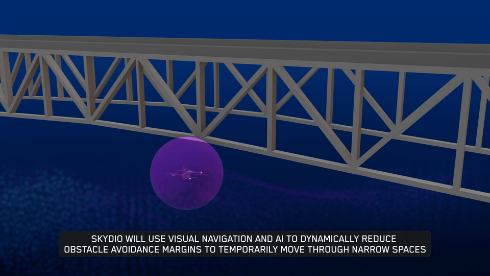
Use Case(s): dynamic obstacle avoidance can be used to move between urban structures or move into buildings in situations when flying overhead is not preferred or optimal based on tactical considerations. Dynamic obstacle avoidance is also ideal for tactical launch situations, such as launch from a hide site, where it allows the X2D to safely navigate through the vegetation around the hide site using obstacle avoidance until it is out of the tree line, where it can then maneuver to provide a clear aerial picture of the object or person of interest.
Stop at structure
The new Stop at Structure feature allows Skydio X2D operators to conduct closer, more controlled inspections. As the X2D approaches an obstacle, it would normally veer away; but with Stop at Structure enabled, the X2D will not perform a course correction within 8 ft (2.5 m) of a structure. Instead, X2D will reduce speed and maintain position, allowing for more precise maneuvering near the structure. Stop at Structure can be toggled on or off, and is available in manual flight and 3D Scan mode.
USE CASE(S): Stop at structure is an excellent feature for obtaining detailed metrology during ship hull inspections. It is ideal for inspecting critical assets such as aircraft, fuel tanks, antenna arrays, roof tops, and a wide variety of infrastructure aboard military installations and government or defense contractor properties.
Conclusion
As Skydio continues to expand autonomous innovation, Federal, DOD, and enterprise customers will continue to benefit from the unparalleled capabilities of Skydio drones. RAS-A Compliance, Map Capture, Crosshair Coordinates, Variable Obstacle Avoidance, and Stop at Structure are powerful tools for conducting critical battlefield missions, enhancing surveillance and reconnaissance, capturing accurate map data, ensuring the safety and security of sensitive areas and personnel, and improving cost-effective inspection practices for asset maintenance. Skydio X2D delivers exceptional performance and reliability. Explore the new and refined features of the Skydio X2D drone and elevate your aerial capabilities today.
Contact us for more information.


