Cloud-Coordinated, Collision-Free: Skydio's Approach to Multi-Drone Airspace Management
 Grace Wu
  Trey Hakanson III
  Devin Hickman
 Problem
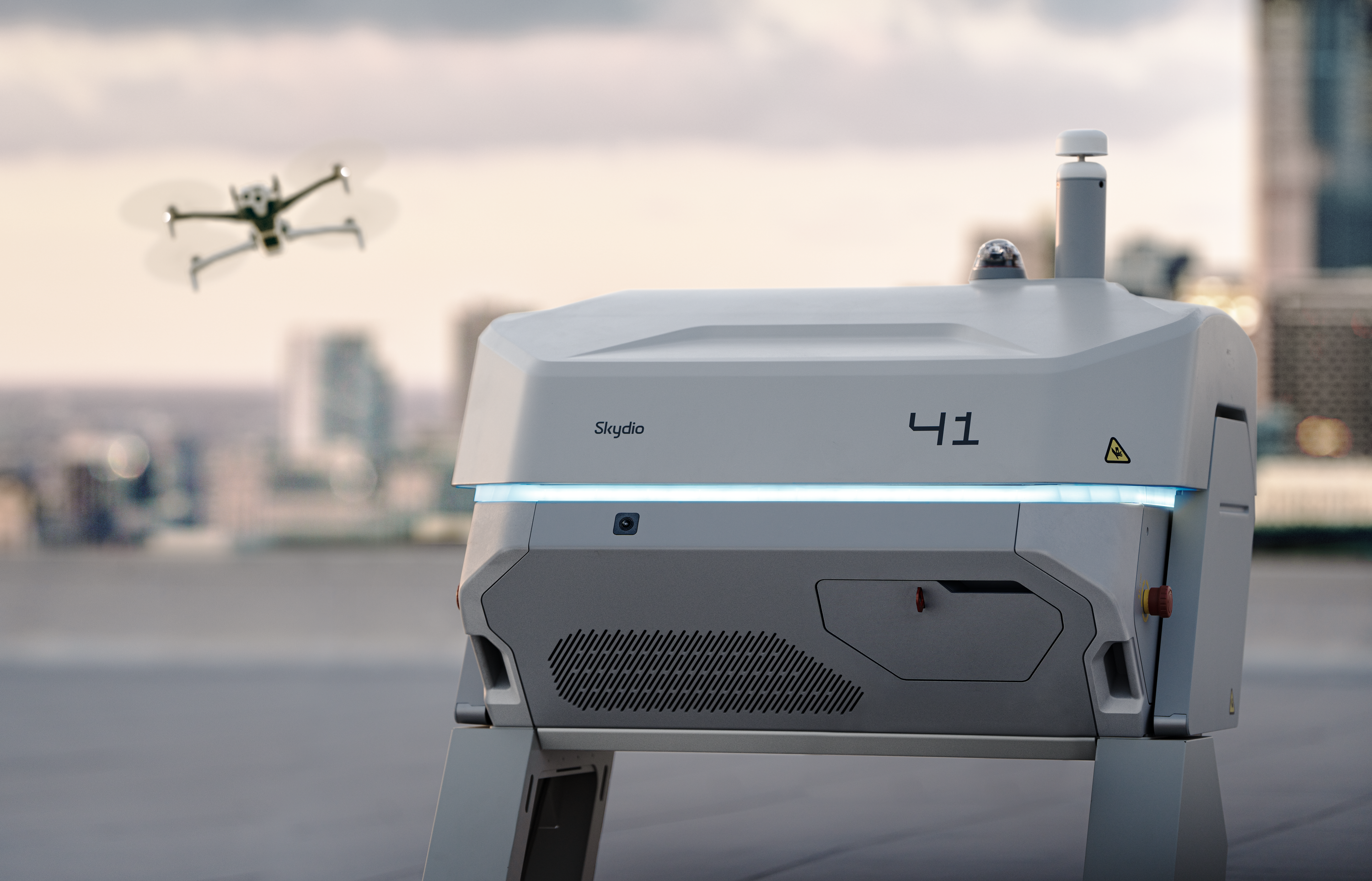
Skydio Dock for X10 is a key enabler in Skydio’s quest to make drones part of the everyday infrastructure underpinning modern civilization. Having drones ready to launch and fly at a moment’s notice under the control of an RPIC (Remote Pilot In Command) located anywhere in the world unlocks many new incident response capabilities. It also greatly simplifies continuous inspection and monitoring for stationary infrastructure like substations, roads, and bridges.
Flying one mission at a time from a single Dock is a powerful capability on its own, but falls far short of the “drones as infrastructure” vision, especially in densely populated urban areas. Changing the default model for incident response and inspection requires that there are drones ready to go at any moment for any mission. That in turn requires many more drones and associated Docks. These Docks are most conveniently placed in a small number of locations because each new site requires another round of planning, permitting, and other paperwork. The best way of realizing drones as infrastructure is thus to pack a bunch of Docks in a small number of tight spaces. We can go even further and use Skydio’s multi-drone operations to allow up to four of these drones to be operated by the same pilot simultaneously. Easy, right?

Unfortunately, flying a large number of drones in the same constrained airspace around a Dock “Hive” creates a lot of localized air traffic. The Big Sky Theory tells us that a collision between two randomly flying drones is very unlikely because the sky is a big three-dimensional space. Flight in urban areas violates the random flight assumption because drones typically need to fly in between large buildings rather than over them. The confined space of a Hive (where Docks can be six feet apart), combined with constant launching and landing, makes the “Big Sky” restricted and congested in practice.
The problem we needed to solve is automatically establishing collision-free paths for all Skydio drones operated by our customers in this environment.
Constraints
Given the success of Skydio's advanced autonomy and obstacle avoidance, it might seem natural to leverage our 360° camera coverage to have drones detect and dynamically plan around each other in flight. This solution is not so straightforward, unfortunately. While our drones can see each other in flight, the perception and planning systems are tuned specifically to maximize speed and flight safety in the static environments in which they usually operate. Avoiding a stationary tree branch while traveling at 20 meters per second is a very different problem from two drones avoiding each other when both are flying at 20 meters per second. A vision-based approach would require drones to fly more slowly, impacting mission effectiveness. The dynamic avoidance aspect also carries the additional complexity of guaranteeing uncoordinated but non-conflicting avoidance maneuvers via pre-computed policies (à la ACAS sXu) — a task made more difficult when operating in possibly cluttered urban environments.
Another answer is to have the drones communicate directly with one another to avoid collisions. Each one could tell all of the others nearby where it is, like a very frequent remote ID broadcast. The UTM standard covers longer-term strategic deconfliction, but does not currently address the needs of real-time tactical deconfliction. We require real-time responsiveness because Skydio drone pilots always have the option of flying manually as the mission dictates. They cannot be held to a pre-filed flight plan.
Solution
We are operating in a crowded environment with some tough constraints, but necessity is the mother of invention, and we have a few key capabilities that make a scalable solution possible. Skydio X10’s (excluding the X10D variant) are cloud-connected. That means Skydio’s Cloud can see their telemetry in real time, make decisions based on that telemetry, and forward critical information to other drones as necessary. X10 can also move in any direction or loiter in place almost instantaneously. We can combine these key characteristics with a deterministic prioritization score to achieve a consistent, safe result. Skydio Cloud routes scores among drones so that all of them know about their neighbors’ relative priorities. Drones that do not have the highest priority pause to let others pass.
This approach has several desirable properties:
- Based on the prioritization score, all drones agree on the same ordering to ensure the highest priority drone can keep moving
- Drones can detect when others become disconnected because they stop receiving messages from Skydio Cloud representing those disconnected drones.
- Disconnected drones always get priority, and the last message they received from Skydio Cloud contains the most up-to-date information about other drones’ possible positions, giving them the best chance to avoid others.
- The highest priority drone only needs to avoid stationary obstacles because all others are paused
This is the current version of airspace deconfliction available to all customers operating Skydio Docks today. It has successfully resolved over 10,000 potential airspace conflicts, mostly during launch and landing maneuvers near Dock hives — about one event every 3.5 hours of flight. A potential conflict does not mean an imminent collision, but rather that two or more drones could collide in the next few seconds if flown directly at one another. Our airspace deconfliction system frees operators from the need to explicitly monitor their immediate surroundings for this class of safety risk.

Scalability
The airspace deconfliction solution needs to fit within a few resource constraints. Bandwidth is at a premium, especially on the link from Skydio Cloud to drones, where deconfliction messages need to be shared with other safety-critical messages like pilot inputs. We also need to process the smallest number of messages possible on each drone to keep down local resource usage. Finally, we need to carefully manage the computations we do in the Cloud because, combined, our customers conduct thousands of flights per day, and that number is growing rapidly. Processing all Skydio drone telemetry in a centralized location and including a lot of ultimately irrelevant traffic from non-proximal drones would eventually make it difficult to meet real-time requirements.
Our approach to solving this problem is to split the traffic as early as possible within Skydio Cloud. We use H3, a geospatial indexing system that partitions the world into hexagonal regions, or geoindices, as the basis for our traffic splitting. We combine H3 with a concept we call a front: a lightweight process that accepts messages (from drones or other services), applies logic, and emits results. Fronts act as programmable points in the data path where we can control how information flows. We combine H3 with fronts to create geofronts, processes responsible for routing traffic for all drones within a given hex. Static geographic boundaries introduce an important edge case. Drones in adjacent hexes can still be on a collision path, even though they fall into different regions. To account for this, we emit drone telemetry into neighboring hexes, ensuring drones near boundaries are still aware of one another in time.
This solution gives us a horizontally scalable solution by limiting the scope for each geofront to a fixed space where a single process can easily handle all relevant traffic. It also gives us a place to define the concept of “nearby” drones. The geofront can run arbitrary code so we can carefully pare down the exchanged messages to the minimum required for safe operations and change that logic as needed without affecting any drone-side code.

Future Work
There is still a lot of work to do on the airspace deconfliction problem. One existing limitation is that drones without the right-of-way stop to let others pass. This maintains our standard obstacle avoidance policy of only considering static obstacles, but it causes unnecessary delays in traffic. The median delay is a little under five seconds, which is significant. An X10D could travel 100 meters at top speed in that time. We will be enabling more pause-free movement in the future, where, coordinated by Skydio Cloud, each drone will dynamically change its planned trajectory to avoid collisions whenever possible.
Another big step for airspace deconfliction is to extend it beyond Skydio drones. We are working toward compliance with the UAS Traffic Management (UTM) standards that will make the skies safe for mixed use with other drone fleets. This will entail not only implementing existing standards, such as ASTM F3548, but also engaging with government and industry stakeholders to fully flesh out these standards in support of a complete interoperable ecosystem. The end result will be emergency incident response coexisting safely and harmoniously with timely delivery of small packages and medical supplies.
If you want to solve the hardest problems in autonomous systems, we're hiring.