


FAQs about X10
Sensors and payloads
What sensor packages are available for X10?
X10 supports three sensor packages:
- VT300-L: Includes a 50 MP wide-angle camera and a 64 MP narrow camera, plus a Teledyne FLIR Boson+ radiometric thermal sensor. Well-suited for inspections and mapping. Includes an integrated LED flashlight to assist in low-light conditions.
- VT300-Z: Includes a 64 MP narrow camera and a 48 MP telephoto zoom camera, plus a Teledyne FLIR Boson+ radiometric thermal sensor. Best suited for Drone as First Responder, extended overwatch, subject search and tracking, and general reconnaissance.
- V100-L: Includes a 50 MP wide-angle camera and a 64 MP narrow camera (same as VT300-L), but without the thermal sensor. Ideal for inspections and mapping when thermal imaging is not required. Includes an integrated LED flashlight to assist in darker conditions.
What are X10's thermal imaging capabilities?
The Teledyne FLIR Boson+ thermal sensor in the VT300-L and VT300-Z payloads is radiometric, meaning it can measure and visualize temperature differences with high sensitivity (<30 mK). This supports detecting heat signatures and performing thermal inspections in darkness and through obscurants such as fog, smoke, or low-contrast environments. These capabilities are commonly used in search and rescue (SAR), emergency response, and Drone as First Responder (DFR) operations.
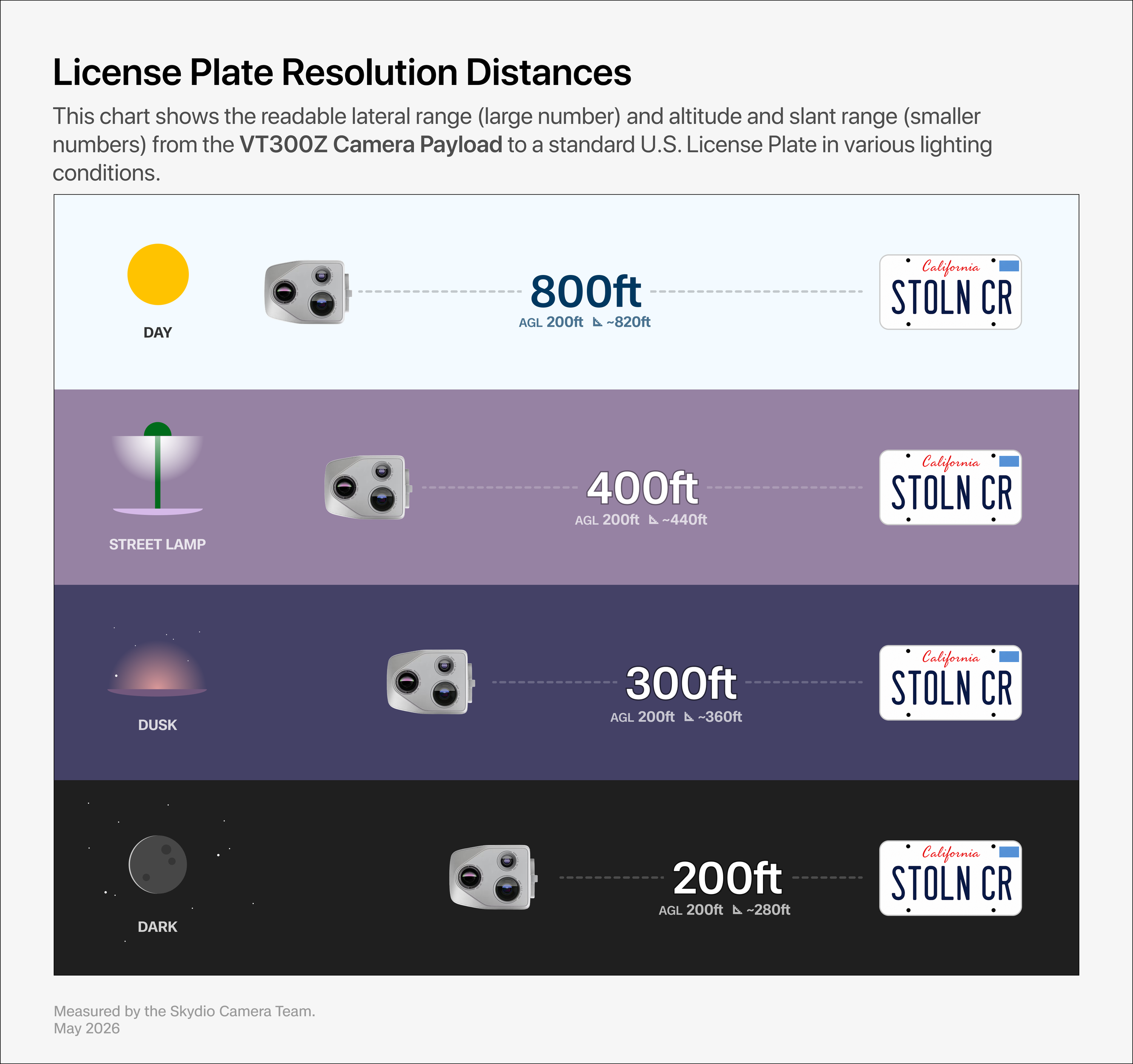
What are the zoom capabilities of X10’s VT300-Z sensor package?
The VT300-Z sensor package includes a 48 MP telephoto zoom camera capable of approximately 128x system zoom. It delivers lossless resolution up to 16x (in 1080p mode). With it, operators can detect a person at 8,200 feet or a vehicle at 7.5 miles. With it, operators can read a license plate at approximately 800 feet.
Lighting and environmental conditions affect sensor package performance. As lighting levels decrease, you may need to adjust your operating height and distance to the object for a clear view.
How accurate is X10 for mapping and modeling workflows?
When equipped with the optional RTK/PPK attachment, X10 is capable of capturing geospatial data with centimeter-level accuracy. This enables precise 2D and 3D reconstruction for applications like photogrammetry, site modeling, and volumetric measurements. Accuracy depends on mission planning, altitude, and use of ground control points.
How long can X10 fly?
Up to 40 minutes depending on payload and environmental conditions. Flight time can be affected by temperature, wind, and mission type.
Can X10 operate in rain, wind, or extreme environments?
Yes. X10 is IP55 rated and tested to fly in light rain, dust, and wind gusts up to 28 mph (45 km/h).
How quickly can I deploy X10?
Skydio X10 can be deployed in under 40 seconds when hand-launched. When deployed from Dock for X10, the drone can be airborne in as little as 20 seconds.
What are the physical dimensions and weight of X10?
Unfolded with propellers: 31.1" x 25.6" x 5.7" (79.0 cm x 65.0 cm x 14.5 cm) Folded without battery: 13.8" x 6.5" x 4.7" (35.05 cm x 16.51 cm x 11.94 cm) Maximum takeoff weight: 5.49 lbs (2.49 kg)
Security and airspace awareness
Are communications with X10 encrypted?
Yes. X10 supports AES-256 encryption for both control links and media transmission, helping ensure secure operations in sensitive or regulated environments.
Does X10 include an ADS-B receiver?
Yes. X10 includes an integrated ADS-B In receiver. When nearby crewed aircraft broadcast ADS-B Out, the drone relays that signal to the pilot’s interface—whether they are flying locally via Controller or remotely through Remote Ops or DFR Command. Operators can view aircraft altitude, heading, bearing, and distance directly on the controller. The system is designed to alert only when aircraft enter your operational area, helping to reduce unnecessary alerts and focus pilot attention where it's needed most.
What GNSS systems does X10 support?
Skydio X10 supports GPS, GLONASS, Galileo, and BeiDou satellite constellations. This improves positional reliability in diverse environments, including partially obstructed or GNSS-challenged areas.
Compliance
Can X10 be flown Beyond Visual Line of Sight (BVLOS)?
Yes. X10 supports advanced operations like BVLOS when flown under FAA-approved waivers. Skydio's Regulatory Services team has helped customers across public safety, infrastructure, and enterprise sectors secure BVLOS approvals using X10 and Dock platforms, with one of the industry's strongest records of success. Our team supports every step of the waiver process—from risk assessment and documentation to submission strategy and FAA engagement.
Is X10 NDAA-compliant?
Yes. X10 is fully NDAA-compliant and designed, assembled, and supported in the United States. It meets federal sourcing requirements for government agencies and critical infrastructure operators.
Does X10 support Remote ID?
Yes. X10 includes a Remote ID module that complies with FAA requirements, allowing the drone to broadcast identifying and location information in real time. This is required for most operations in U.S. airspace and helps support advanced workflows such as BVLOS when used with waivers and appropriate software.
Storage and media
Is there a watermark on X10 video recordings?
Yes. X10 offers optional watermarking, which can be enabled in Skydio Cloud. It applies a persistent, uneditable watermark to recorded video files that includes the timestamp, drone serial number, sensor package, and camera used. This helps support evidence integrity and audit trails, and is not visible during live views.
How is flight data stored and managed?
Skydio X10 stores images, telemetry, and flight logs on encrypted internal storage (AES-256) and removable SD cards. Internal memory ensures mission data is preserved even without an SD card. Media and log files can be exported via USB-C or SD card, with options to select individual or batch flights. When connected to WiFi data can automatically sync using Media Sync, allowing teams to access and analyze mission data centrally. All data is encrypted at rest and in transit, and remains onboard until exported, uploaded, or deleted per organizational policy.
What video resolutions does X10 support?
X10 captures video in up to 4K resolution (3840 x 2880) at 30 fps and 24 fps in low light, with options for Full HD (1080p) and thermal video (640 x 512) depending on the camera in use. It supports both H.264 and H.265 codecs within the standard MP4 container, ensuring compatibility across most workflows.
Operators can fine-tune settings like bitrate, frame rate, HDR, and exposure, and optionally generate low-resolution video (LRV) copies for fast review and sharing. These flexible recording formats are optimized for inspection, thermal analysis, documentation, and secure media workflows
Software and integrations
Can I initiate flight based on a trigger from another system?
Yes. Skydio systems support triggered flight initiation through integrations with third-party platforms. For example, drones can be launched automatically when a call is received through dispatch software or when a sensor (e.g. gunshot detector or motion alert) is activated.
Can I fly X10 from a third-party software system?
No. Because of embedded AI-driven Autonomy and its impact on flight experience, Skydio X10 can only be operated through Skydio Flight Deck (Controller) or Remote Flight Deck (Remote Ops or DFR Command).
How do I get data from X10 into the systems where I need it?
Skydio Extend helps teams connect drone workflows to the systems you already use—whether that's evidence management software, inspection platforms, photogrammetry tools, or cloud storage. Making it easy to upload images, video, and flight logs, or stream live video to other systems. For teams with unique needs, Skydio offers open APIs and services to build custom integrations.
What software features are included with X10?
X10 includes a full suite of software tools designed for autonomous flight, data collection, and integration—at no additional cost:
- Skydio Autonomy for obstacle avoidance, 360° environmental awareness, and GPS-denied flight
- Map Capture for capturing high-resolution nadir and oblique imagery optimized for 2D orthomosaic generation
- Onboard Modeling for generating low-resolution 3D previews on-device, supporting faster field decision-making
- Visual Return-to-Home and Track in Place for responsive autonomous flight management
- In-flight tools including offline maps, HDR, bitrate control, and low-resolution video (LRV) generation
These features are included with every X10 system. Advanced software capabilities such as 3D Scan, remote operation via Remote Ops or DFR Command are available as optional add-ons.
Where can I find a list of integrations?
Visit the Skydio Integrations Catalog to explore compatible tools and platforms.
Attachments
What attachment options are available for X10?
X10 has four modular attachment bays with standardized connector ports. Available attachments include:
- RTK/PPK GPS – Unlocks centimeter-level accuracy for workflows like surveying, reconstruction, and photogrammetry.
- Spotlight – Unlocks visibility in dark environments for night inspections, search and rescue, or scene documentation.
- Speaker – Unlocks real-time or pre-recorded audio communication for evacuations, public address, or tactical coordination.
- NightSense – Unlocks obstacle avoidance in total darkness. The visible-light version improves inspection visibility; the infrared variant supports light-sensitive or covert operations.
- Parachute – Unlocks added safety for operations over people or sensitive areas by slowing descent in emergencies.
- Dropper – Unlocks precision payload delivery for radios, medkits, or other equipment in remote or urgent scenarios.
Connect Fusion+ – Unlocks higher uplink bandwidth and link resiliency by adding a second 5G connection—ideal for remote or congested environments.
Can I add my own attachments to X10?
Yes. Skydio provides an Attachment Interface Control Document (ICD) for X10, which enables developers to build custom attachments. It includes detailed mechanical, electrical, and power specifications to ensure proper integration with the drone and its software systems. Learn more at skydio.com/developer-tools.
Connectivity
How does Skydio X10 ensure reliable connectivity wherever I need to fly?
Reliable, resilient connectivity is essential for every mission. Whether you're operating in a dense urban corridor, across long-range utility infrastructure, or in a remote response scenario, Skydio Connect provides flexible connection options to keep you in control:
- Connect SL: Point-to-point radio link (up to 7.5 miles/12 km) with low latency.
- Connect 5G: Built-in cellular connectivity that keeps you flying through signal shadows and beyond line-of-sight range limits. Works on 5G/LTE networks with approved SIMs from carriers like AT&T, FirstNet, KDDI, NTT, T‑Mobile, T‑Mobile WPS, and Verizon.
Skydio Connect Fusion intelligently fuses two communication links, Connect SL and one cellular connection, to deliver higher-throughput, more reliable video and control. It automatically selects and blends the best available path in real time, helping operators maintain connectivity in environments with fluctuating signal strength or line-of-sight challenge
Connect Fusion+ adds a second 5G connection to the drone, enabling multi-network fusion for higher throughput, increased uplink resiliency, and improved streaming performance in remote or high-interference environments.
Remote operations
Can I share livestreams from X10?
Yes. X10 supports real-time video streaming through Skydio Remote Ops and DFR Command. Operators can share livestreams using ReadyLinks — browser-based links that can be securely distributed to authorized viewers — or stream directly to integrated platforms like Fusus and Axon.
How do I fly X10 remotely?
Skydio X10 supports both docked and hand-launched remote flight through two software options: Skydio Remote Ops and DFR Command. With Remote Ops, users can securely launch, control, and monitor flights from any web browser—whether the drone is deployed from a Dock for X10 or launched by someone else in the field. DFR Command builds on this capability with additional tools for public safety, including AR overlays, live mapping, and automated dispatch-driven routing. These tools allow remote operators to access live video through the browser and take control in real time, including support for mission coordination via AR overlays and remote route planning, supporting Drone as First Responder (DFR) and remote inspect.