Methods of scene documentation
In the world of criminal and accident investigation, thorough forensic analysis and documentation of evidence are paramount to establishing the facts in a case and providing a fair and accurate representation of the scene for the triers of truth. Traditionally (and for some agencies, currently), crash and crime scene measurements have been captured by hand. After identifying and marking essential items for evidentiary purposes, sketching a scene and using tape measures to capture spatial information can take hours. Often, some measurements are difficult, if not impossible, to obtain due to challenging conditions and cluttered environments, leading to less-than-desired accuracy. Once the on-scene work is complete, the measurements from the hand sketch are manually entered into a software program to generate a 2-dimensional computer-aided diagram to provide a bird's eye view of a scene for a jury.
The evolution of scene documentation
Over the past few decades, scene documentation has advanced beyond hand measurements to using devices that capture the coordinates of points throughout the scene. Total stations are very popular with traffic accident investigations to reduce the time required on scene and provide more information (with greater accuracy) than is gathered with hand measurements. However, total station data is captured point-by-point, and often, requires two (2) investigators to complete the documentation. The resulting data can be imported into diagramming software to generate a diagram similar to one from hand measurements, but it requires less manual input.
Next to the scene of investigations came terrestrial laser scanners. With the ability to generate 3D point clouds, agencies are incorporating these devices to capture their scene in a way they couldn’t before. In a line-of-sight device, you must move the scanner multiple times to capture a scene’s entirety, and each scan generates millions of x,y, and z coordinates. The output is a digital twin, with high accuracy and precision, and the ability to create 2D diagrams and conduct forensic analysis in a 3D environment, such as shooting incident reconstruction or crush analysis. While the output meets the demand of achieving results that contribute to the desired “CSI Effect,” the data capture is time-consuming, the files are large, and it requires a significant amount of back-end work and proficiency to process and register the scans and create deliverables.
Adding drones to the toolkit
Most recently, law enforcement agencies have incorporated drone technology. With fast data capture and the ability to create 2D diagrams and 3D point clouds, drones provide a quick, efficient, and easy-to-use means of documenting and preserving an incident.
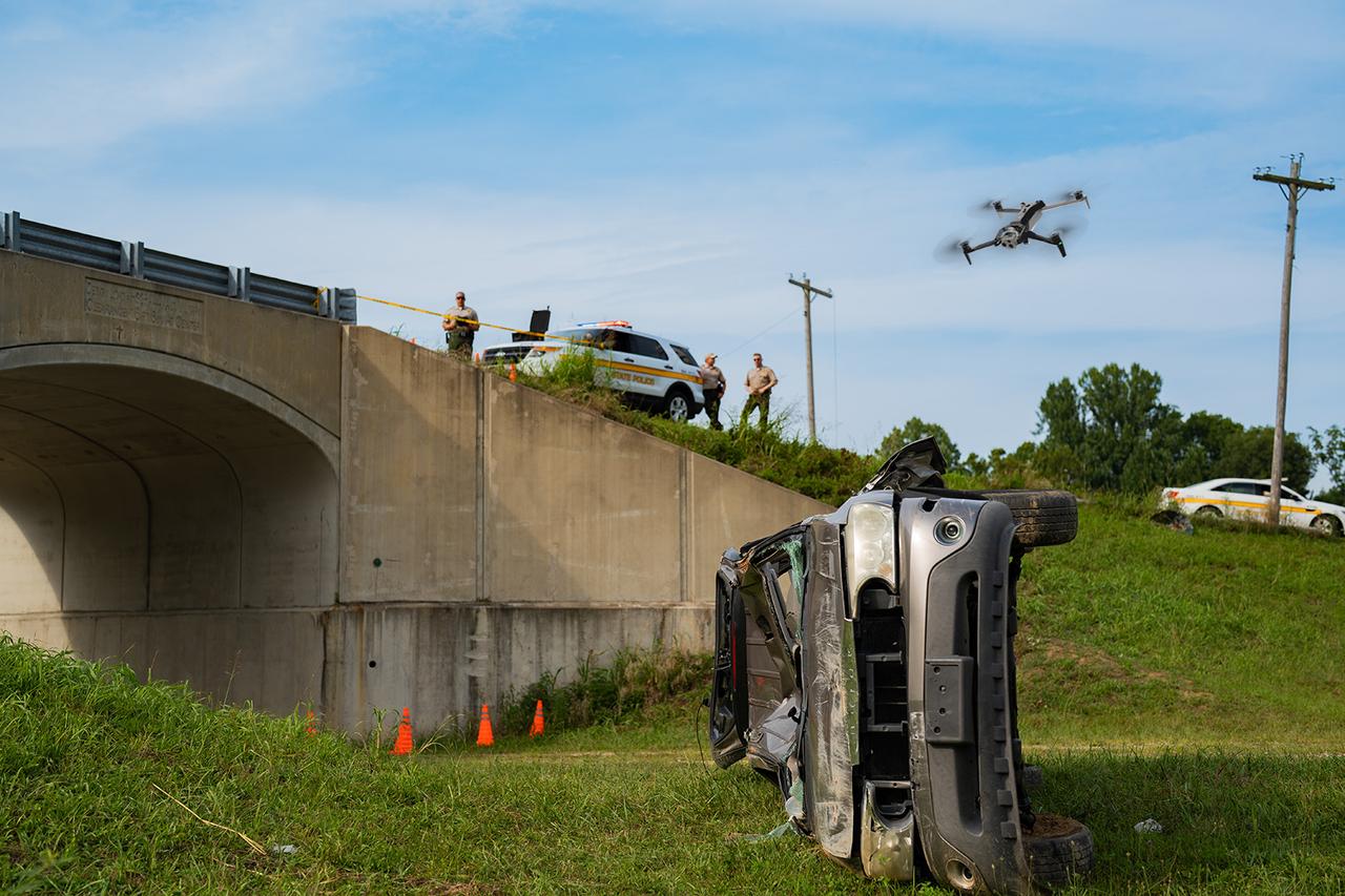
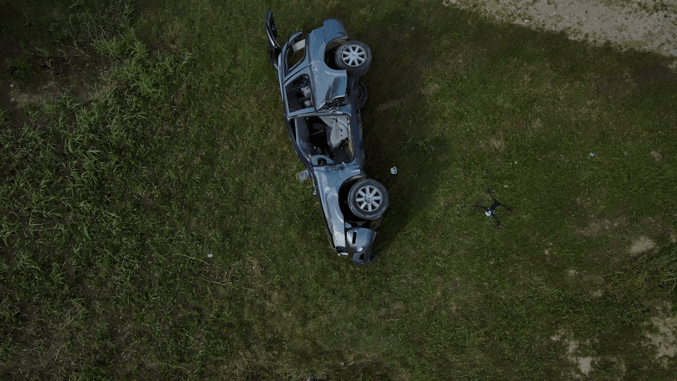
While traffic units have been using drones for some time, more recently, crime scene units have been using them to document outdoor scenes. They are an increasingly valuable tool for large and complex scenes that cover a lot of ground or are difficult to access. For example, an incident in mountainous terrain can be challenging to capture, with comprehensive perspectives, by traditional means. Additionally, many shooting investigations can span multiple blocks of jurisdiction, making measurement capture and diagramming a long and challenging process. Drones can be deployed quickly to capture information in difficult or dangerous locations, increasing the efficiency and output for courtroom presentations.
With the ability to quickly generate a 3D environment from the captured photographs, drones are an ideal scene analysis tool for the use of force or officer-involved incidents. The 3D data output provides the viewer with a realistic representation of the scene, allowing them to understand better the spatial relationships between people and objects, the perspectives of those involved, and an overall better context of the incident. This data can be used to supplement witness statements and provide a better understanding of an officer's perspective beyond the narrowed fixed views of a body camera. These perspectives are impossible to visualize with only photographs and 2D diagrams.
3D reconstruction with drone technology
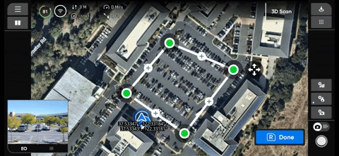
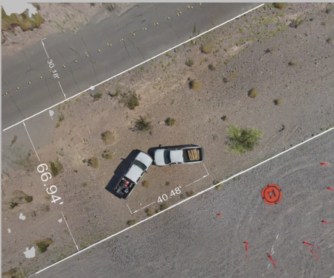
When a drone is sent on a mapping mission for an outdoor scene, all of the individual photographs captured can be aligned to create one image: an orthomosaic. This image can then be imported into diagramming software as the foundation of the 2D diagram. Think of it as a highly detailed satellite image captured of the scene. Map Capture makes this process easy by providing the ability to preplan a flight using a top-down map view. After navigating to the scan area on the map, the user creates boundaries for the drone to fly a lawnmower path and capture the scene autonomously.
The orthomosaic image created with Map Capture can be exported from the drone and imported into forensic software. Using drawing tools, trace the scene’s layout and drop your models and evidence onto the image. Adding measurements and annotations to this image provides a quick 2D diagram of the scene to supplement scene photography and visually assist a jury in understanding the scene as it was on the day of the incident.
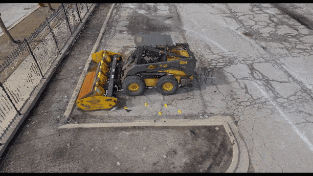
Individual 2D images and orthomosaic images aren’t the only deliverables you can obtain from accurate drone capture. With 3D Scan, once you set the pillars and volume of the scene, the drone will autonomously fly around that area and capture images, from various perspectives, to be imported into a photogrammetry software. A photogrammetry engine will convert those 2D images into a 3D point cloud; a world of x,y, and z coordinates that create a comprehensive 3D reconstruction of the scene.
Once the 3D Scan mission is complete with the X10, within minutes, the user can generate an Onboard Model to view the 3D data captured before clearing the scene and have the confidence you need to know you aren’t missing any important information.
Challenges of low-light documentation
The National Highway Traffic Safety Administration (NHTSA) indicates that, in general, the evening and nighttime see more fatal crashes than the daytime. Inherently, this requires additional tools, lighting, and methods to complete scene documentation effectively. While some AI-powered drones can operate autonomously and navigate in the dark for you, drone cameras still rely on ambient light to capture detailed images. As with ground-based cameras, drones still require supplemental lighting for comprehensive details of night scenes. You may still want to set up lights around your scene to illuminate areas of importance, especially those with evidentiary value.
LiDAR meets photogrammetry
If you are currently using any of the other forensic investigation tools, whether it be hand measurements or coordinate data from a total station, they can be used in conjunction with drone data. The technologies combined provide enhanced scene documentation and allow you to clear the scene faster.
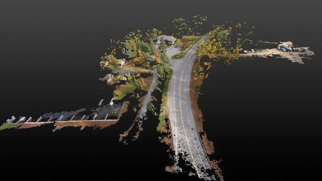
For example, if you are capturing high-detailed laser scans of motor vehicle crush damage, you can use the drone to capture images of the roadway pre- and post-impact and decrease the time spent on the scene. After processing the drone images in photogrammetry software, the generated 3D point cloud can be merged with a laser scanner point cloud for a comprehensive 3D representation of the scene. The combined point clouds can be imported into forensic software for additional reconstruction, analysis, and the creation of multiple different deliverables for a courtroom presentation.
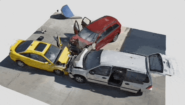
In the crash below, the scene was captured by both a FARO Focus scanner and a drone. The drone images were processed in FARO Zone 3D Expert software and that point cloud was merged with the FARO point cloud. The combined point clouds were used to create diagrams and complete additional forensic scene analysis in the software.
Using drone data for courtroom presentations
By providing fast, efficient, and accurate data capture, drones enable a thorough and comprehensive representation of scenes that enhance courtroom presentations and aid in jury understanding. Preparing deliverables for the court has never been more streamlined, as drones can quickly generate orthomosaics for 2D diagrams and comprehensive 3D point clouds, allowing for the most efficient and precise scene documentation possible. In many investigations, photographs aren’t enough. Generating a 3D model of a scene, and being able to create additional animation of the events or a forensic reconstruction of the scene, provides the jury with more information than ever before.
A look ahead
For a crime scene or major accident investigator, you’ve all experienced a shift that felt as though it would never end. Or the on-call status that kept you away from home for weeks at a time. Capturing better data, faster, is key to accurately and efficiently documenting a scene and this is easily achieved by adding drones to your workflow. As we continue to embrace these advancements, the legal process benefits from clearer, more accurate evidence presentation, ultimately leading to more informed decisions and just outcomes. The integration of drone technology into forensic documentation marks a significant leap forward in the pursuit of justice, promising a future where the truth is more readily and accurately revealed.
Learn about drones for crash and crime scene documentation or watch a demo of crash scene documentation.