


US-Compliant Drones for the AEC industry
Keep projects moving. Even when requirements change.
Move to an American-made, NDAA-compliant drone platform without disrupting inspection, mapping, or documentation workflows.
AEC teams working across transportation, utilities, energy, buildings, and federally funded projects need drone programs that can meet procurement expectations without slowing field work. The challenge is not just replacing aircraft. It is preserving the workflows your teams already depend on.
Replace the drone. Keep the workflow.
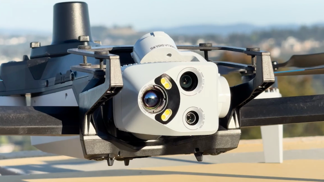
Skydio X10 fits into your existing capture-to-deliverable pipeline: similar process, same deliverables, minimal friction. Dock, remote operations, and regulatory support are ready when you are.
Capture stays familiar.
Plan the mission on the cloud or on the controller, and let X10 execute the flight autonomously. Teams keep the mapping, modeling, and inspection workflows they already know—with Skydio autonomy handling consistent data capture across complex structures and active sites.

Deliverables stay accurate.
RTK/PPK workflows, terrain follow capture, and precise image geometry help teams produce consistent maps, models, and inspection records. Process data in the tools already in use and deliver outputs with confidence.

Programs become scalable.
Standardize capture workflows and centralize mission data across every office, region, and project type with Skydio Cloud. Set missions once, redeploy them when needed, and stop chasing files across SD cards and hard drives.

Precision you can repeat.


Trusted by leading construction, engineering, and infrastructure teams.


Scale coverage. Without scaling complexity.
With Dock for X10, aerial capture becomes automated and repeatable. Flights run on a schedule or on demand, so teams get trusted, time-stamped data that stays consistent across every phase of the project.
Fly when the site needs data, not when crews are available.*
*with appropriate FAA approvals
From waivers to deployment, you have a team behind you.
Get BVLOS-ready with expert guidance.
Our regulatory services team guides your BVLOS pathway to support autonomous operations at scale.

More than support—partnership.
From deployment to expansion, our team helps you get operational quickly and stay successful as you grow.

American-made. Enterprise-ready
Designed, assembled, and supported in the U.S. for teams that need secure operations, reliable supply, and long-term program stability.

Don’t let drone requirements slow the next project.
Resources to support your transition

Predictable Precision Starts with Effective GSD

Solving rolling shutter: high-precision mapping with Skydio X10

Precision in flight: Skydio X10 RTK accuracy testing
Beyond the baseline: Achieving precision mapping with Skydio’s RTK/PPK technology
FAQs
Is the Skydio X10 NDAA compliant and/or BlueUAS certified?
Yes. Skydio X10 is designed, assembled, and supported in the United States and is NDAA compliant. It has also received BlueUAS certification. If your project is federally funded or subject to procurement restrictions, Skydio is built to qualify.
See our security policy here
Can Skydio X10 replace a DJI Matrice for mapping and inspection work?
For AEC workflows including site mapping, progress documentation, infrastructure inspection, yes, directly. X10 supports RTK/PPK positioning, terrain-aware capture, and autonomous mission planning comparable to Matrice-series operations. The camera system, flight autonomy, and data outputs are built to produce the deliverables your teams already rely on. The transition is a platform switch, not a capability downgrade
Does Skydio work with Pix4D, DroneDeploy, and Esri?
Yes. Skydio integrates with the major photogrammetry processing platforms AEC teams already use, including Pix4D, DroneDeploy, Esri SiteScan, Propeller, Bentley, gNext, and Trimble Business Center. Your data capture platform changes, your downstream processing workflow doesn't have to.
Does Skydio support BVLOS operations for infrastructure projects?
Skydio X10 is capable of BVLOS operations, and Skydio's regulatory services team provides direct support for teams pursuing FAA waivers. BVLOS can dramatically reduce the number of crew deployments required. We guide you through the waiver process so regulatory complexity doesn't become a program bottleneck.
Is a mechanical shutter required for survey-grade mapping?
A mechanical shutter can reduce motion distortion, but it’s not the only path to survey-grade outcomes. Skydio X10 uses a high-resolution sensor and applies on-capture rolling-shutter correction to stabilize geometry for clean alignment in photogrammetry processing.
In practice, mapping accuracy depends on the overall system: flight plan, overlap, GSD, RTK/PPK, and processing QA, rather than any single component.
Why does Skydio X10 cost more than DJI and is it worth it for my team?
Yes, X10 can cost more upfront. But for AEC teams on federal, public-sector, or enterprise projects, the risk of compliance issues, delays, or rework can outweigh the initial price difference. X10 helps teams meet higher security expectations, capture more consistent site data, and create savings that compound across the project lifecycle.